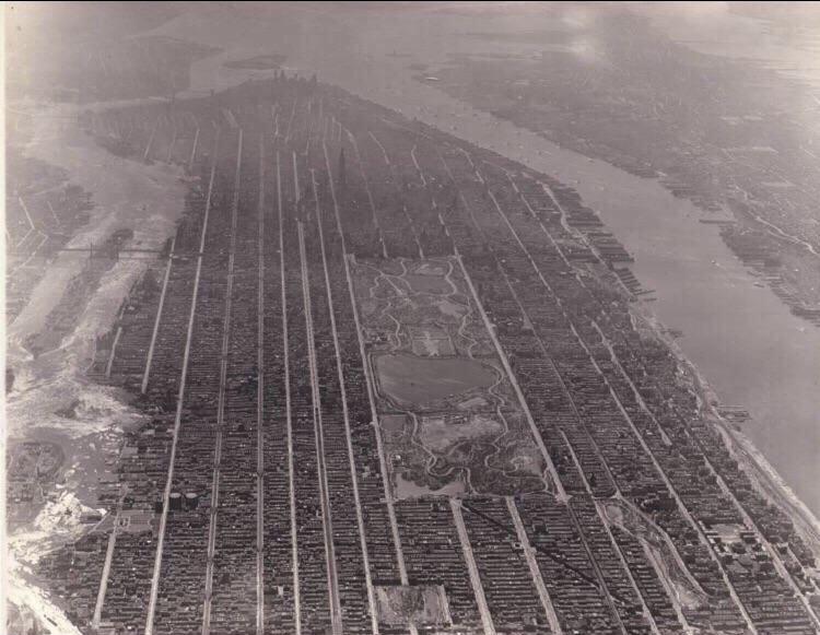
1931年的曼哈顿
1931年的曼哈顿 (750x581)
评论 (80)
andrewx1,603 赞2020/11/26
Geez, that picture shows why the Empire State Building was truly mind-boggling when it opened. It just TOWERS over everything else.
天呐,这张照片完美诠释了帝国大厦刚落成时为什么那么让人叹为观止。它简直把周围所有建筑都比下去了。
ManfredsJuicedBalls551 赞2020/11/26
Agreed. Most of the skyscrapers were in downtown, not midtown, and even they were dwarfed by it. I'd imagine seeing it then was kind of like if we went up to the Burj Khalifa today. Just impossibly tall, yet there it is, standing in front of us.
同意。当时大多数摩天大楼都集中在下城,而不是中城,就算在那些楼面前,它也显得鹤立鸡群。我觉得那时候看它,就跟咱们现在去看哈利法塔的感觉差不多。高得离谱,可它就这么实打实地立在眼前。
notbob1959194 赞2020/11/26
Here is an aerial view from around the same time but from the opposite direction and while the Empire State Building still stands out it isn't as overwhelming: 
这里还有一张差不多同一时期,但从相反方向拍的航拍图。虽然帝国大厦依然显眼,但视觉上的压迫感没那么强了:
SupremelyBetterThanU181 赞2020/11/26
I think OP’s pic is a tad older, half the stuff around Central Park isn’t there in yours.
我觉得楼主那张图稍微早一点,你这张图里中央公园周围一半的东西都没出现。
koshgeo91 赞2020/11/26
When I went looking for a higher-resolution version of OP's image, the reverse image look-up described it as "1910", but that isn't much to go on. Here's the higher-resolution version I found, which should help: [ ]() The Empire State Building looks like it's there, and was built in 1931, so the original date might be right. Edit: It's still pretty confusing, but I think it can be narrowed down. had a good idea that it might be the Met Life Tower, which in the absence of other buildings would imply 1910, but the building in question is definitely to the west (right) of the street running along the eastern edge (left side) of Central Park, which if I'm reading the map right is 5th Avenue. The Empire State Building is located just to the west (right) of 5th Avenue, which fits with what is in the picture. The Metropolitan Life Insurance tower is located 1 block to the east of 5th Ave, on Madison Ave, which is not consistent with what is in the photograph. It should be 1 street over to the left, so I'm pretty sure that the tall building is the Empire State Building and therefore the photo is later. You can look in Google Maps at the 3D view and confirm the relative position without too much difficulty even though there are many more buildings now.
]() The Empire State Building looks like it's there, and was built in 1931, so the original date might be right. Edit: It's still pretty confusing, but I think it can be narrowed down. had a good idea that it might be the Met Life Tower, which in the absence of other buildings would imply 1910, but the building in question is definitely to the west (right) of the street running along the eastern edge (left side) of Central Park, which if I'm reading the map right is 5th Avenue. The Empire State Building is located just to the west (right) of 5th Avenue, which fits with what is in the picture. The Metropolitan Life Insurance tower is located 1 block to the east of 5th Ave, on Madison Ave, which is not consistent with what is in the photograph. It should be 1 street over to the left, so I'm pretty sure that the tall building is the Empire State Building and therefore the photo is later. You can look in Google Maps at the 3D view and confirm the relative position without too much difficulty even though there are many more buildings now.我刚才试着搜了下楼主那张图的高清版,以图搜图的结果显示是“1910年”,但这信息量实在太少了。
这是我找到的高清版本,希望能帮到大家:[]()
图里看起来有帝国大厦,而它是1931年才建成的,所以最原始的那个日期(1910年)可能不对。
编辑:情况确实挺让人糊涂的,但我感觉能把时间范围再缩小点。 提了个好思路,说那可能是大都会人寿大厦,如果周边没别的建筑,那时间点确实会指向1910年左右。但照片里那栋楼明显是在中央公园东侧边缘(左侧)那条街的西边(右侧),如果我没看错地图的话,那条街应该是第五大道。帝国大厦正好位于第五大道的西边(右侧),这跟照片里的情况对得上。
大都会人寿大厦是在第五大道东侧一个街区外的麦迪逊大道上,这跟照片里的位置不符。按理说它应该在左边再隔一条街,所以我挺确定那栋高楼就是帝国大厦,因此这张照片的拍摄时间应该更靠后。
你可以去谷歌地图上开个3D模式看一下,虽然现在楼多多了,但确认一下相对位置其实不难。
]()
图里看起来有帝国大厦,而它是1931年才建成的,所以最原始的那个日期(1910年)可能不对。
编辑:情况确实挺让人糊涂的,但我感觉能把时间范围再缩小点。 提了个好思路,说那可能是大都会人寿大厦,如果周边没别的建筑,那时间点确实会指向1910年左右。但照片里那栋楼明显是在中央公园东侧边缘(左侧)那条街的西边(右侧),如果我没看错地图的话,那条街应该是第五大道。帝国大厦正好位于第五大道的西边(右侧),这跟照片里的情况对得上。
大都会人寿大厦是在第五大道东侧一个街区外的麦迪逊大道上,这跟照片里的位置不符。按理说它应该在左边再隔一条街,所以我挺确定那栋高楼就是帝国大厦,因此这张照片的拍摄时间应该更靠后。
你可以去谷歌地图上开个3D模式看一下,虽然现在楼多多了,但确认一下相对位置其实不难。-wen-24 赞2020/11/26
Sure has me baffled. Chrysler Building was finished 1930 but it doesn't look like it's there yet, although it does look like there is something that could be it during construction - the plot didn't have anything significant before. Also, NY had a LOT of big buildings under construction by 1930, so I think you'd see more evidence of that (demolition plots/construction sites etc). Not to mention the photo looks very dated for 1930, but not bad enough for a 1910 aerial shot. My instinct is to say both are wrong and it's somewhere in the mid 20s, but I can't deny that building looks far more like the ESB than the old Waldorf-Astoria.
说实话,我也被整懵了。克莱斯勒大厦是1930年完工的,但图里看起来还没它,虽然在那儿隐约能看到点像是在建的东西——不过那块地在建楼之前也没什么标志性的建筑。而且,1930年那会儿纽约有一大堆大楼在施工,我觉得照片里应该能看到更多施工迹象(拆迁空地或者施工现场之类的)。更别说这照片看起来年代感太重,不太像1930年的,但又还没破旧到1910年航拍的那种程度。我的直觉是这两个时间点都不对,应该是在20年代中期,但我也不得不承认,那栋楼看起来确实比旧华尔道夫酒店更像帝国大厦。
thisisincorrectinfo29 赞2020/11/26
The photo is from 1910, and that tall building is the Metlife tower. [https://en.wikipedia.org/wiki/Metropolitan\_Life\_Insurance\_Company\_Tower](https://en.wikipedia.org/wiki/Metropolitan_Life_Insurance_Company_Tower)
这张照片摄于1910年,那个高楼就是大都会人寿保险公司大厦。
https://en.wikipedia.org/wiki/Metropolitan_Life_Insurance_Company_Tower
notbob195919 赞2020/11/26
I know it doesn't look like there is stuff there but I think it is just because in the posted photo everything is dark but in the photo in my comment the buildings are white with reflected sunlight. The posted photo is definitely from 1931. You can see the [Empire State Building](https://skyscraperpage.com/cities/?buildingID=23) which was finished in 1931. You can see [20 Exchange Place](https://skyscraperpage.com/cities/?buildingID=231) which was also finished in 1931. You can see [40 Wall Street](https://skyscraperpage.com/cities/?buildingID=5902) which was finished in 1930 and I am pretty sure I can barely make out the [Chrysler Building](https://skyscraperpage.com/cities/?buildingID=83) which was also finished in 1930. But you can not see [70 Pine Street](https://skyscraperpage.com/cities/?buildingID=131) which was finished in 1932. 
我知道看起来那儿好像啥都没有,但我寻思那纯粹是因为原帖照片里光线太暗了,而在我评论里发的这张图上,那些建筑在阳光反射下是白色的。原帖照片绝对是1931年拍的。你看,帝国大厦(Empire State Building)就在那儿,它是1931年完工的。你还能看到交易所广场20号(20 Exchange Place),它也是1931年盖好的。还有华尔街40号(40 Wall Street),这栋是1930年完工的,而且我挺确定自己隐约能辨认出克莱斯勒大厦(Chrysler Building),它也是1930年落成的。但你确实看不到松树街70号(70 Pine Street),因为那是1932年才建好的。
[已删除]39 赞2020/11/26
[内容已删除]
[已删除]60 赞2020/11/26
From certain angles it still kind of does. Looking at the skyline from the NJ turnpike it’s startling how big that building looks. It almost looks bigger from far away than it does when you’re right underneath it, which I don’t really understand.
从某些角度看,它确实还有点那种感觉。从新泽西收费公路(NJ turnpike)看天际线的时候,那栋楼看起来规模大得惊人。甚至远看比你站在它底下看还要显大,这点我真是搞不太懂。
OldSparky12439 赞2020/11/26
这是经典的“长度 vs. 周长”难题。当你站在它旁边,你看到的只有周长。
[已删除]30 赞2020/11/26
她就是这么说的。
spotila727 赞2020/11/26
这是1931年纽约已建成的建筑图片。
帝国大厦真他妈雄伟

795 赞2020/11/26
More people [lived in Manhattan at that time](https://en.wikipedia.org/wiki/Demographics_of_Manhattan) than live there now.
那时候住在曼哈顿的人比现在还多。
316 赞2020/11/26
[内容已删除]
101 赞2020/11/26
"...Regis surely you are joking? This is the million dollar question and there are two choices? And the question is 'Was the population of Manhattan higher in 1910 than it is today?'. Well I guess I'm about to be a millionaire!"
“……瑞吉斯,你不是在开玩笑吧?这就是那个百万美元的问题,而且只有两个选项?问题的核心是‘曼哈顿 1910 年的人口比现在多吗?’。好吧,看来我要成百万富翁了!”
52 赞2020/11/26
> New York City *Manhattan*
> 纽约市
*曼哈顿*
24 赞2020/11/26
People gotta keep in mind that in growing popular central locations residential buildings often get taken over (or demolished and building something new) by companies. So yeah, if you think about residential buildings in Manhatten it might not be that surprising the amount of people that actually lived there used to be higher.
大家得记着,在那些越来越火的中心地段,住宅楼经常会被公司收购(或者直接拆了盖新的)。所以啊,如果你想想曼哈顿的住宅楼,你会发现那儿以前住的人数其实比现在多,这也没啥好惊讶的。
16 赞2020/11/26
slums on slums on slums on slums
贫民窟连着贫民窟,简直是贫民窟的海洋。
159 赞2020/11/26
Makes since as more buildings start going up for places of business rather than residential.
这倒是讲得通,毕竟现在盖起来的楼越来越多是给公司办工用的,而不是给人住的。
92 赞2020/11/26
Also just piling people into tenements and apartments without really considering health and safety standards.
还有就是直接把人往廉租公寓里硬塞,根本就没怎么考虑过健康和安全标准。
20 赞2020/11/26
🎵A tenement, a dirty street
Walked and worn by shoe less feet🎵
🎵廉租房,脏街道,
赤足行过,步履蹒跚🎵
16 赞2020/11/26
And importantly the advent of the subway meant people could live outside of Manhattan and commute into the city.
还有很重要的一点是,地铁的出现意味着人们可以住到曼哈顿外面,然后再通勤进城。
21 赞2020/11/26
whats you wonder what will happen when working remote becomes the norm. No reason to spend a lot of money on a huge office in Manhattan, and therefore no reason for super wealthy people to buy apartments. A massive amount of money will leave the city. The consequences might not be all that bad, people will still want to live there for the city life, and property values/rent will go down. So the city might evolve more than implode. But i can still totally imagine it just becoming a mess like detroit.
你很好奇当远程办公成为常态后会发生什么吧。公司没理由再花大钱在曼哈顿租那种超大办公室了,所以超级富豪们也就没理由再买那里的公寓。大量的资金会从这座城市流失。
后果可能没那么糟糕,人们还是会为了城市生活想住在那儿,房价和租金也会随之下降。所以这座城市可能是在进化,而不是走向崩溃。但我完全能想象它变得像底特律那样一团糟。
19 赞2020/11/26
I doubt that it will be that extreme. More likely that parts of cities that are lower density and less expensive will thrive while downtown areas decline. This is happening in Los Angeles now.
我怀疑不会变得那么极端。更有可能是城市里密度较低、租金较便宜的地段会繁荣起来,而市中心区域会衰落。洛杉矶现在就在发生这种情况。
38 赞2020/11/26
That's wild. What was vacancy like then? I imagine almost 0 if not more people cramming into smaller spaces. There are so many empty apartments in NYC right now.
那太离谱了。那时候的空置率是怎样的?我猜几乎为零,甚至可能更多人挤在更小的空间里。纽约现在有好多空着的公寓。
87 赞2020/11/26
Keep in mind residential buildings were either tenements, where dozens of families would live on the same floor or even the same room! Or an entire extended family would live in the whole building. My grandparents owned a small three story building in East Harlem and the entire family lived in it but it was hardly enough space for a 4 person family.
记住,当时的住宅楼要么是那种贫民窟公寓,几十户人家挤在同一层楼甚至同一个房间里!要么就是一整个大家族住满整栋楼。我祖父母在东哈莱姆区有一栋小三层,全家人都住在里面,但这空间对一个四口之家来说都勉强够用。
32 赞2020/11/26
god that'd be the life. imagine living in the same building as your cousins and uncles n shit? que chingon
天哪,那日子才叫爽啊。想象一下跟你堂表兄弟和叔伯们住同一栋楼是种什么体验?简直酷毙了(que chingon)。
18 赞2020/11/26
[内容已删除]
18 赞2020/11/26
[内容已删除]
605 赞2020/11/26
Looks like some weird template for a game like cities skylines
看起来像是什么游戏的奇葩样板房,比如《都市:天际线》那种。
340 赞2020/11/26
This how I design my cities in city skylines, which eventually leads to unsolvable traffic issues
我在《都市:天际线》里就是这么搞城市规划的,结果最后全是治不好的交通瘫痪。
167 赞2020/11/26
water axiomatic payment quicksand punch touch squeeze carpenter oatmeal profit
这种所谓的“水”是公理化的,支付过程就像流沙一样让人心慌,这一拳打在触碰挤压的木匠燕麦利润上。
*(注:原文为无意义的乱码词汇组合,缺乏逻辑含义,以上翻译已尽可能保留字面对应的荒诞感和口语化语气。)*
24 赞2020/11/26
but no, trains are too expensive and I don't *feel* like taking the bus. Give me more lanes! Make Traffic WORSE Again!
但不行啊,火车太贵了,而且我才懒得去坐公交车呢。给我多修几条车道!让交通再次变得更烂吧!
101 赞2020/11/26
Well, dead bodies and trash are piling up despite cemeteries and garbage collection facilities on every corner. ...maybe I should solve this gridlock after all
哎,明明到处都有墓地和垃圾处理厂,结果尸体和垃圾还是堆得像山一样。
……看来我还是得亲手解决这坨烂摊子。
43 赞2020/11/26
I end up solving those problems with a tornado, meteor, and earthquake. Sometimes I toss in sink holes.
我最后都是直接扔个龙卷风、陨石或者地震把这些问题搞定。有时候我还会再加几个天坑。
23 赞2020/11/26
Ah, the death trash wave, a classic. They should really improve the way traffic and settling works
啊,尸体垃圾潮,老经典了。开发商真该好好优化一下交通和居民搬入机制了。
28 赞2020/11/26
There is a mod that randomizes the age of immigrants. That way you avoid death waves when you build new neighborhoods. The traffic manager presidents edition is great for creating dedicated turn lanes and different yield patterns and stuff which makes traffic way easier to manage.
有个模组可以随机化移民的年龄。这样你在建新社区的时候就能避免“死亡潮”了。Traffic Manager: President Edition 这个模组也超棒,可以用来设置专用转弯车道、调整各种让行规则之类的,让交通管理轻松多了。
26 赞2020/11/26
[内容已删除]
16 赞2020/11/26
I thought Simcity 4 before you go high density.
我觉得在搞高密度建筑之前,还是先去玩玩《模拟城市4》吧。
273 赞2020/11/26
I can't wait for the day that geospatial and AI will combine to comb the Internet for old photos to stitch and create a Google Earth-like street level view back in time.
我等不及想看那一天了:地理空间技术和人工智能强强联手,在网上搜罗各种老照片,把它们拼凑起来,还原出一种类似谷歌地球、能回溯时光的街景视角。
180 赞2020/11/26
isn't far off from what you're looking for. Edit: [this website](https://www.oldnyc.org/) has done exactly what you described with NYC from 1800-2000. Edit 2: it's complete shit to use on mobile
这个板块和你想要找的东西差不离。
编辑:[这个网站](https://www.oldnyc.org/) 做的东西和你描述的一模一样,里面有 1800 到 2000 年间的纽约影像。
编辑 2:这玩意儿在手机上用简直烂透了。
23 赞2020/11/26
[内容已删除]
146 赞2020/11/26
Tells you just how much a 1931 New Yorker's mind would be blown if they were dropped in the middle of Manhattan today. Makes you wonder what we would think of NYC in the year 2110.
你想想,如果一个 1931 年的纽约人被扔到今天的曼哈顿中心,那得有多震撼。这不禁让人好奇,如果我们去到 2110 年的纽约,又会作何感想。
99 赞2020/11/26
Or how mind-blowing it would be for one of us to visit 1931 Manhattan. All the longshoreman bars on the west side, the Italian, Irish, and Jewish gangsters, jazz clubs, and speakeasies. Watching Boardwalk Empire is the closest you can get.
或者反过来想,如果咱们能去 1931 年的曼哈顿逛逛,那得多带劲。西区的码头工酒吧,意大利、爱尔兰和犹太黑帮,爵士乐俱乐部,还有地下酒吧。看《大西洋帝国》基本就是你能体验到的极限了。
48 赞2020/11/26
Probably not so glamorous as it sounds
听起来可能没那么光鲜亮丽。
21 赞2020/11/26
Y’all think NYC smells bad now, add 700,000 more people and get rid of all modern regulations and innovations
你们觉得现在的纽约味儿已经够冲了是吧,那再往里塞 70 万人,还没了所有现代化的监管和创新试试。
36 赞2020/11/26
I never said it would be glamorous, it would be gritty af. But also fascinating.
我可从没说过那地方会光鲜亮丽,那儿绝对会是粗粝又操蛋的。但同时也会非常迷人。
27 赞2020/11/26
[内容已删除]
36 赞2020/11/26
It might be under water at that point
搞不好到那时候它都已经在水底下了。
145 赞2020/11/26
If you look closely, you can see the Knicks losing.
你仔细看的话,能看到尼克斯队又在输球了。
106 赞2020/11/26
[内容已删除]
88 赞2020/11/26
Most are like 4-6 stories
大多数大概也就4到6层楼高吧。
24 赞2020/11/26
i think that is a little bit of an illusion though there were many more smaller buildings and not nearly as many large ones. you can browse through 80000 buildings at street level from these 1940 tax photos. [https://nycma.lunaimaging.com/luna/servlet/view/all?sort=borough%2Cblock%2Clot%2Czip\_code&os=0](https://nycma.lunaimaging.com/luna/servlet/view/all?sort=borough%2Cblock%2Clot%2Czip_code&os=0)
我觉得这有点像幻觉,虽然那时有很多小楼,但大楼却没那么多。你可以通过这些 1940 年的税收照片,在街景层面浏览 80000 栋建筑。
15 赞2020/11/26
There are a few larger buildings but it’s definitely hard to see. I worked at the Beresford on 81st and Central Park West back in the early 2000s. It was finished around 1930 and is 23 floors. Still have a newspaper from 1927 that I found while fitting an ac into a cubby hole in the lobby. It was such a great find.
有几栋大楼确实比较大,但真的很难看清楚。我 2000 年代初在 81 街和中央公园西的 Beresford 大楼工作过。它大概是 1930 年建成的,有 23 层。我还有一张 1927 年的报纸,是我在给大厅里的壁橱装空调时找到的。真是个了不起的发现。
17 赞2020/11/26
Buildings you could afford to live in. What a concept
你能负担得起住进去的房子。真是个概念。
42 赞2020/11/26
The few buildings left from that era are some of the most ludicrously expensive in the city. Density means affordability.
那个年代留存至今的建筑,随便哪一栋都是全城贵得离谱的地界。人口密度高才意味着房价负担得起。
61 赞2020/11/26
[Side-by-side with a modern view]( ) **Approximate altitude**: 10,000 feet
) **Approximate altitude**: 10,000 feet[今昔对比图]()
**估算海拔**:10,000英尺
)
**估算海拔**:10,000英尺47 赞2020/11/26
Having lived in the patchwork that is modern day Atlanta, GA... Those parallel streets just look so damn nice!
在亚特兰大那片支离破碎的现代城区住过之后……
看看这些平行的街道,看起来真TM带感!
37 赞2020/11/26
Not naming every street Peachtree helps too.
不把每条街都叫“桃树街”(Peachtree)也有帮助。
15 赞2020/11/26
It is a city pattern actually called ‘gridiron’ like grid :)
这其实是一种叫“网格状”(gridiron)的城市规划模式,就像那个网格(grid)一样 :)
15 赞2020/11/26
All because they had a mind of what to do in the early 1800's, and had that planned out just as Manhattan had 100,000 people living on the island.
这全是因为他们在 19 世纪初就有了远见,而且早在曼哈顿岛上住满 10 万人时,就已经把这些规划好了。
32 赞2020/11/26
[内容已删除]
12 赞2020/11/26
What's with the one diagonal street beneath central park though?
中央公园下面那条斜着的马路是怎么回事啊?
23 赞2020/11/26
That looks like St. Nicholas Ave. Which is actually North of Central Park (this view is facing South) Often times the roads that follow weird slants (like Broadway, Broadway and its weird kinks are the perfect example.) were there before the grid pattern was laid out and originally followed Native American routes.
那看起来是圣尼古拉斯大道(St. Nicholas Ave)。其实它是在中央公园北边(这个视角是朝南看的)。
很多顺着奇怪斜坡延伸的路(比如百老汇,百老汇那些古怪的弯道就是绝佳的例子)都是在曼哈顿的网格规划出台之前就存在的,而且最初都是沿着原住民的路线修建的。
18 赞2020/11/26
St. Nicholas Avenue. While Manhattan, especially north of Houston Street, is gridded [(thanks to what was laid out in the Commissioners' Plan of 1811,)](https://en.wikipedia.org/wiki/Commissioners%27_Plan_of_1811) there were a few holdovers, like that, and Broadway. The oddballs were mainly because they were the main roads in and out of Manhattan in the 1700's and first half or so of the 1800's, so when the grid made it's way up Manhattan in the second half of the 1800's, those streets stayed since they were (at the time) important arteries in and out of Manhattan that were already well settled into place. Central Park wasn't even supposed to be accounted for, but in the mid-1800's, it was decided a big green space was needed in the city, and Central Park was put in before the grid got up that far.
那是圣尼古拉斯大道。虽然曼哈顿,特别是休斯顿街以北的地方,是有网格规划的[(多亏了1811年的委员会规划)](https://en.wikipedia.org/wiki/Commissioners%27_Plan_of_1811),但还是留下了一些“遗珠”,像那条路和百老汇就是。这些“异类”之所以存在,主要是因为它们在18世纪到19世纪上半叶左右是进出曼哈顿的主干道,所以当19世纪下半叶网格规划铺开到曼哈顿上城时,这些路就被保留了下来,因为它们在当时已经是进出曼哈顿、且早已定型的重要交通动脉了。
中央公园原本甚至都不在规划考量之内,但到了19世纪中期,人们决定城市需要一大片绿地,于是就在网格还没延伸到那一带之前,把中央公园给安进去了。
8 赞2020/11/26
Thank you. I enjoyed seeing this.
谢谢。看得挺过瘾的。
7 赞2020/11/26
I'm a bit confused by that giant iceberg to the left
左边那座巨大的冰山看得我有点懵。
6 赞2020/11/26
[内容已删除]
6 赞2020/11/26
How the hell did Spiderman get around back then?
那时候蜘蛛侠到底是怎么到处乱窜的啊?
5 赞2020/11/26
Wish I could go back in time and buy the lots surrounding the park.
真希望我能穿越回去,把公园周围的地皮全给买了。
5 赞2020/11/26
Obviously the depression era United States would’ve been a difficult time to be alive, but I find 1930’s Manhattan more appealing than current day Manhattan.
说实话,大萧条时期的美国日子肯定很难熬,但我还是觉得30年代的曼哈顿比现在的曼哈顿更有魅力。
4 赞2020/11/26
东河看起来浪特别大,水挺急的。好奇后来它是怎么/为什么变得这么平静的。
4 赞2020/11/26
嚯,要是搁这儿,蜘蛛侠估计都得费劲。
4 赞2020/11/26
这照片不是1931年的,是1910年的。那其实是位于23街和麦迪逊大道的大都会人寿大厦,1909年就建好了。[https://en.wikipedia.org/wiki/Metropolitan_Life_Insurance_Company_Tower](https://en.wikipedia.org/wiki/Metropolitan_Life_Insurance_Company_Tower)
3 赞2020/11/26
历史航拍图永远是我了解过去的最爱方式。那种像真实地图一样重现过去的感觉简直太迷人了。
3 赞2020/11/26
[这是一个展示1940年代纽约的网站](https://1940s.nyc/map#13.69/40.7093/-73.99397)
2 赞2020/11/26
感谢分享这张照片。那时我家人就住在曼哈顿。
2 赞2020/11/26
在早年间,楼层越高租金越便宜。直到电梯发明出来,情况才完全反过来了。
2 赞2020/11/26
为什么这些照片总是用土豆画质的手机拍的?/s