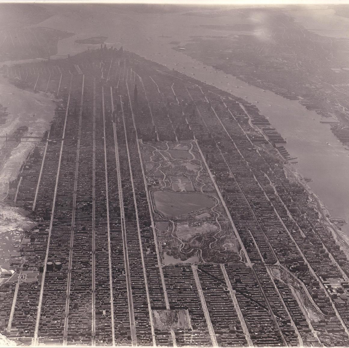
摩天大楼林立前的曼哈顿,1931年
1931年,尚未被摩天大楼占据的曼哈顿。
评论 (94)
thetruephysic2,624 赞11 天前
Love this photo, including the very period-specific zeppelin hanging out in front of the Statue of Liberty.
超爱这张照片,尤其是那架背景味儿十足、就悬在自由女神像前的齐柏林飞艇。
SaffronRnlds893 赞11 天前
Always an interesting thing to look back on. They were ***convinced*** zeppelins were going to be a huge and permanent fixture for society.
回过头来看总觉得挺有意思的。当时的人们可是深信不疑,觉得齐柏林飞艇以后肯定会成为社会生活中极其重要且长久存在的一部分。
trashpanda6991604 赞11 天前
I'm still convinced they should be. Like, imagine how cool it would be to travel in a zeppelin. At a chill pace, like a campervan in the sky.
我到现在还觉得它就该是那样。你想想,坐齐柏林飞艇旅行得有多酷啊。那种悠闲的节奏,简直就是空中的房车。
DuvalHeart325 赞11 天前
They'd be really useful in the United States for intra-regional travel. A flight from Orlando to Atlanta takes half a day even though flight time is short. An airship would work just as well with fewer hazardous emissions and more comfort.
它们在美国的区域内交通方面会真的很有用。从奥兰多飞亚特兰大,哪怕飞行时间其实很短,但算上各种折腾也要花掉半天。要是换成飞艇,效果差不多,排放还少,坐着也更舒服。
NoobMusker69401 赞11 天前
> and more comfort Would it though? Yes the original zeppelins had cabins and lounges and a restaurant etc, but that was in the 1930s. Old airplanes were also much more comfortable space wise than today's. A modern zeppelin company would cram as much people as possible to maximize profits and thus cabins would have the same layout as airplane ones, you'd just be stuck in there longer.
> 而且更舒服
真的会吗?没错,最初的齐柏林飞艇确实有客舱、休息室和餐厅什么的,但那可是20世纪30年代的事了。那时候的飞机在空间上也比现在的宽敞得多。
现在的飞艇公司为了利润最大化,肯定会塞进去尽可能多的人,所以客舱布局跟现在的飞机没啥两样,你只不过是在里面被困的时间更久罢了。
astral-dwarf144 赞11 天前
Spirit Airship
精神飞艇(Spirit Airship)
Harry_Tuttle125 赞11 天前
**NOTHING BEATS A BLIMP2 HOLIDAY 💥🔥**
**没有什么比得上“飞艇2号”假期了 💥🔥**
username_tooken91 赞11 天前
> Yes the original zeppelins had cabins and lounges and a restaurant etc, but that was in the 1930s. Old airplanes were also much more comfortable space wise than today's. I remember watching iirc an old Columbo episode from like the 1970s and being gobsmacked that planes used to have multiple stories, cocktail lounges, and freaking electric pianos for people to play.
> 是的,最初的齐柏林飞艇确实有客舱、休息室和餐厅等等,但那可是20世纪30年代的事了。那时候的旧式飞机在空间舒适度上也比今天的飞机强多了。
我记得自己看了一集老版《神探可伦坡》(如果没记错的话,大概是70年代的),当时简直惊呆了,因为以前的飞机居然有上下两层、鸡尾酒休息室,甚至还有给乘客弹着玩的电钢琴。
ProfessorEtc49 赞11 天前
The Hindenburg had a smoking lounge.
兴登堡号当年甚至还有一个吸烟室呢。
Watchout_itsahippo42 赞11 天前
To be fair, it wasn’t just the lounge that was smoking.
平心而论,当时不止休息室里烟雾缭绕。
benjaminovich32 赞11 天前
All that very much still exists. It's just that air travel became more accessible over time, and thus less exclusive. Even the cheapest ticket back then was more expensive than business-class today
那些东西确实都还存在。只不过随着时间推移,航空旅行变得普及了,也就没那么高端了。
那时候即使是最便宜的机票,也比现在的商务舱还要贵。
Cla16883 赞11 天前
They would have to make it more attractive than a plane.
他们得把(火车/其他交通工具)搞得比飞机更有吸引力才行。
-malcolm-tucker80 赞11 天前
Paint nipples on the front? Turn them into giant boobs?
在前面画上乳头?把它改成一对巨乳?
_bobby_cz_newmark_23 赞11 天前
Nah, just draw the ol' fighter jet eyes-and-teeth-grin on it.
不,直接画上那种经典的战斗机眼睛和咧嘴笑的涂装就行。
Theron320618 赞11 天前
How? You would still have to spend 3 hours going through security and the trip would take 5x as long and get cancelled all the time due to bad weather. There are a number of extremely good reasons why blimps disappeared as soon as larger fixed wing aircraft became viable.
怎么做?
你还是得花3个小时过安检,而且行程时间会是原来的5倍,还总因为天气不好被取消。
飞艇在大型固定翼飞机变得可行后就迅速消失,这背后是有很多非常充分的理由的。
queso61938 赞11 天前
Hear me out though. Trains. You can make them super comfortable, carry large amounts of people, and if you elevate the track it won’t need to slow down for car crossings. Also probably safer …
但先听我说完。火车。你可以把它搞得超级舒服,载客量又大,而且要是把轨道架高,就不用为了过车流而减速了。而且大概率更安全……
INS0MNI526 赞11 天前
Way up high in the sky, but the wind won’t blow, you really shouldn’t go, it only goes to show..
在云霄高处,但风儿不会吹,你真的不该去,这一切只说明了……
HotTubMike27 赞11 天前
Yea, it's pretty cool to imagine taking a Zeppelin from Europe to the United States or Brazil or wherever in the 1920s or 1930s. Obviously, some voyages ended in tragedy but most didn't.. was probably awesome as long as you weren't on one of those unfortunate ones.
没错,想象一下在1920或1930年代坐齐柏林飞艇从欧洲去美国、巴西或者其他什么地方,确实挺酷的。
显然,有些旅程以悲剧告终,但大部分并没有……只要你不幸没碰上那几趟(出事的),体验估计棒极了。
Shame4Lyfe27 赞11 天前
Its cool to imagine but the reality is they were extremely limited in how much they could carry, so much so that most passengers would be lucky if they could bring a change of clothes. There was also no running water and the bathrooms empties into the sky (saves weight not having water tanks). Youre thinking modern camper van in the sky, but its more accurate to thinking of them like a flying sailboat from the 17th century. Completely at the mercy of the elements, limited in carrying capacity and distribution, and stinking to high heaven on any real length of journey (although the smoking room mightve masked the stank somewhat)
想象一下挺酷的,但现实是它们的载重极其有限,甚至有限到大部分乘客能带一套换洗衣服就算走运了。当时也没有自来水,厕所是直接往天上排泄的(不装水箱是为了省重)。
你以为那是天上的现代露营车,但其实把它们想象成17世纪的飞天帆船会更准确。完全看老天爷脸色,载重和配重都受限,只要航程稍微长一点点,里面就臭气熏天(虽然吸烟室可能多少能遮盖点那股味儿)。
falconzord78 赞11 天前
The Empire State Building's top dome was meant to be a Zeppelin docking terminal so the rich could get off right in midtown Manhattan
帝国大厦顶部的穹顶原本是打算做成齐柏林飞艇的停靠站,这样富人们就能直接在曼哈顿市中心下飞艇了。
JamminJcruz26 赞11 天前
Marketing Ploy. Even then they knew it wasn’t feasible
营销噱头罢了。那时候他们心里就清楚这玩意儿根本行不通。
BarryHotelHouseBand16 赞11 天前
They build a port on top of the Empire State building for airships. It never got used, probably because of winds at that height.
他们在帝国大厦楼顶建了个飞艇停靠塔。这地儿从来没用过,估计是因为那个高度风太大了吧。
ComprehensiveSoft2773 赞11 天前
It’s chillin.
还挺悠闲的。
itsfunhavingfun21 赞11 天前
Oh the humanity!
天呐,太惨了!
Jumpy_Ad_446015 赞11 天前
I can’t see it in the image, can you point it out to me?
我在图里看不见,你能指给我看看吗?
lorenoline83 赞11 天前
[Hope this helps](https://imgur.com/gallery/manhattan-1931-zeppeli-pAica9f)
[希望这个能帮到你](https://imgur.com/gallery/manhattan-1931-zeppeli-pAica9f)
BR0METHIUS30 赞11 天前
Quite helpful, yes.
挺有帮助的,确实。
1,527 赞11 天前
It’s amazing they kept the park amongst all the prime real estate
真绝了,居然能在这么多黄金地段里保留出这么大个公园。
758 赞11 天前
Once the rich people surrounded it, it was safe.
等有钱人搬到周围把它围起来,这地方自然就安稳了。
628 赞11 天前
Reddit moment. There were no rich people surrounding the park when the land was set aside in the 1850s. It was a rocky uneven swamp and it was considered shit land. By 1900 it was already protected and well developed into a park and the rich people followed.
典型的红迪(Reddit)时刻。
当这块地在1850年代被划出来的时候,周围根本没有有钱人。那时候这儿就是片坑坑洼洼的沼泽地,妥妥的烂地一块。等到1900年,它已经受到了保护,并被开发成了一座像样的公园,之后才引来了那些有钱人。
327 赞11 天前
It was also explicitly intended to be public to compete with European cities. Other parks like Gramercy were only for residents (rich people), and Gramercy in particular remains private. There's plenty of good reasons to criticize the economic reality of Central Park (the destruction of Seneca Village, for instance). But "Central Park only exists because rich people lived around it" is not just bad history, it's like... Anti history. Like the exact opposite of what occurred. True brain rot.
当初规划时就明确要把公园设为公共空间,好去跟欧洲的那些城市竞争。
像格拉梅西公园(Gramercy)这种地方,当时只对附近的居民(也就是有钱人)开放,格拉梅西到现在甚至都还是私有的。
批评中央公园背后的经济现实确实有很多充分的理由(比如当年拆毁塞内卡村那档子事)。但说什么“中央公园之所以存在,纯粹是因为周围住着有钱人”,这不仅是史盲,简直就是……反智。完全是在扭曲历史,跟事实背道而驰。简直是脑子进水了。
32 赞11 天前
There are many ways to be wrong.
犯错的方式有千百种。
23 赞11 天前
And our species is so good at finding every single one of them!
而我们人类呢,偏偏又特别擅长把每一种错误都给犯个遍!
69 赞11 天前
Reddit right-wing revisionist history counter-moment conveniently leaving out the most important parts... In the 1850s, wealthy elites, William Cullen Bryant (editor of the Evening Post) and Andrew Jackson Downing (a famous landscape architect) spent years writing editorials, pressuring the city to set aside that specific "useless" acreage to create a world-class park that would mirror European high society and provide them a private escape from the crowded downtown.
By 1900, the transformation was complete. After decades of massive construction, the elite moved their mansions to the park's edges, successfully turning a rocky swamp into a gold mine. The city used eminent domain and pushed out Black Americans from Seneca Village, along with Irish immigrants, German immigrants, and poor laborers (under compensating them during the process).
Reddit 上这波右翼的历史修正主义逆流,还真是有够“巧”的,偏偏把最关键的部分给漏了……
在 19 世纪 50 年代,像威廉·卡伦·布莱恩特(《晚邮报》编辑)和安德鲁·杰克逊·唐宁(著名景观设计师)这样的权贵精英们,花了多年时间撰写社论,施压市政府划出那片所谓的“无用”土地,目的是建一座世界级的公园,好对标欧洲的上流社会,给他们自己提供一个远离市中心拥挤喧嚣的私人避风港。
到 1900 年,改造大功告成。经过几十年的大兴土木,精英们把豪宅搬到了公园边缘,成功地把一片乱石沼泽变成了“金矿”。市政府动用了征收权,把塞内卡村(Seneca Village)的黑人居民,以及爱尔兰裔、德裔移民和底层劳工统统赶走(过程中还给他们的补偿少得可怜)。
38 赞11 天前
Seneca village covered less than 0.7% of what is now central park. lol Nothing you said contradicted their comment. Redditor moment.
塞内卡村的占地面积还不到现今中央公园的 0.7%。笑死。
你说的这些根本没反驳对方的观点。
典中典的 Reddit 键盘侠时刻。
28 赞11 天前
Again, right-wing revisionists history conveniently leaving out the human aspect and context of that time (massive racism and discrimination). It's like saying the heart is only 0.5% of your body weight so it doesn't matter if you remove it. For those Black New Yorkers in 1853, Seneca Village wasn't just 5 acres of land that they were losing, it was one of the only places they could own property and legally vote. The small size didn't make the displacement any less of a targeted strike on their political and economic independence. In 1821, NY state law required Black men to own at least $250 in property to vote (a requirement white men didn't face). Owning a home in Seneca Village was a literal "voter registration card." Of the 100 Black voters in all of New York City in 1847, 10% lived in Seneca Village.
又来了,右翼的历史修正主义者又在“刻意”忽略当年的具体情况和人文背景(那时候可是大规模的种族主义和歧视)。
这就好比说心脏只占你体重的 0.5%,所以摘了也无所谓一样。对于 1853 年的那些纽约黑人来说,塞内卡村不仅是他们失去的 5 英亩土地,更是他们少数能拥有房产并合法投票的地方之一。面积小并不代表这种拆迁不是针对他们经济和政治独立性的精准打击。
1821 年,纽约州法律规定黑人男性必须拥有价值至少 250 美元的财产才有权投票(白人男性则没有这个限制)。在塞内卡村拥有房产,在那儿简直就是“选民登记证”。1847 年,全纽约市总共只有 100 名黑人选民,其中 10% 都住在塞内卡村。
40 赞11 天前
So...10?
20 赞11 天前
[内容已删除]
23 赞11 天前
No, it's more like saying "this guys body got crushed" when in reality he only broke his pinky toe. You made it sound like the 5 acres of land that is seneca village is representative of the 843 acres of land now makes up the park - the vast majority of which was Dutch, French, and English Owned. Edit: Also... 10 voters in a city with +60,000 eligible voters. LOL Even bigger lol, less than 10% of the 1,600 people displaced to build central park were black.
不,这就像是说“这哥们儿身体被压碎了”,而实际上他只是断了个小脚趾一样离谱。
你刚才那话说的,好像塞内卡村(Seneca Village)那5英亩土地能代表现在整个中央公园那843英亩一样——而这片区域绝大部分地皮原本都是荷兰人、法国人和英国人的。
编辑:
还有……在一个拥有超过6万名合资格选民的城市里,竟然只有10个投票者。笑死。
更搞笑的是,当初为了建中央公园被赶走的1600人里,黑人占比还不到10%。
284 赞11 天前
They didn’t „keep it“ as though it’s the remnant of undeveloped land. They wiped out a neighborhood of Black landowners called [Seneca Village](https://en.wikipedia.org/wiki/Seneca_Village) to create it.
他们可不是“保留了它”,搞得好像这是什么没开发的原始土地残留一样。他们当时是直接夷平了一个叫[塞内卡村](https://en.wikipedia.org/wiki/Seneca_Village)的黑人业主聚居区,才建成了现在的公园。
227 赞11 天前
Link says Seneca Village was 82nd to 89th, one avenue wide (7 city blocks) out of the total 59th to 110th, 5th Ave to 8th (153 city blocks) that were displaced for Central Park. So who was living on the other 146 blocks? The link also explicitly says that Seneca Village itself was inhabited by Irish and German immigrants. What the link does not share is that both Weeksville (now Crown Heights) Brooklyn and Newtown (now Elmhurst) Queens were larger black communities than Seneca Village, so if the goal was targeted racial displacement it would have been built in Brooklyn or Queen, not Manhattan. As always, Americans turn a class struggle into a much more myopic racial one, because the latter conveniently allows us to avoid recognition of how you get exploited by the rich whether that rich is Bezos or Jay-Z and how your material conditions stay the same whether that politician looks like you or not.
链接里说塞内卡村(Seneca Village)位于第 82 街到 89 街,宽度为一个街区(7 个城市街区),而中央公园的总范围是从 59 街到 110 街,从第 5 大道到第 8 大道(共 153 个城市街区),这些地方全都被拆迁了。
那剩下的那 146 个街区里住的都是些什么人?
链接里还明确说了,塞内卡村本身也住着爱尔兰和德国移民。
链接里没提到的是,当时布鲁克林的维克斯维尔(Weeksville,现在的皇冠高地)和皇后区的纽敦(Newtown,现在的埃尔姆赫斯特)其实都是比塞内卡村规模更大的黑人社区,所以如果目标真是针对性的种族驱逐,那公园早该修在布鲁克林或皇后区,而不是曼哈顿了。
美国人老是这样,总喜欢把阶级斗争缩窄成眼界狭隘的种族问题。因为后者能让我们巧妙地避开一个事实:无论那个富人是贝索斯还是 Jay-Z,你被剥削的本质是一样的;无论那个政客长得跟你像不像,你的物质生活条件都不会有什么改变。
66 赞11 天前
Directly from the link: >Seneca Village was a 19th-century settlement of mostly African American landowners in the borough of Manhattan in New York City, within what would become present-day Central Park. > Land ownership among Black residents was much higher than that in the city as a whole: more than half owned property in 1850, five times the property ownership rate of all New York City residents at the time. Many of Seneca Village's Black residents were landowners and relatively economically secure compared to their downtown counterparts in the Little Africa neighborhood by Greenwich Village. You’re calling it a class struggle, but it was explicitly economically secure Black Americans that were displaced through eminent domain. At this time, Irish Americans also faced racial discrimination. >Park advocates and the press began to describe Seneca Village and other communities in this area as "shantytowns" and the residents there as "squatters" and "vagabonds and scoundrels"; the Irish and Black residents were often described as "wretched" and "debased". It’s disingenuous to imply that race did not play a part in the selection of this tract of land specifically. Edit: And to your counting of the city blocks, saying that Seneca Village was wiped out to create Central Park doesn’t mean that it comprised the entirety of the land that would become Central Park. >Elsewhere in Central Park, the impact of eviction was less intense. Some residents, such as foundry owner Edward Snowden, simply relocated elsewhere. Squatters and hog farmers were the most affected by Central Park's construction, as they were never compensated for their evictions. Racism is part of American history and we can’t ignore it.
直接引用链接里的内容:
> 塞内卡村是 19 世纪纽约市曼哈顿区的一个定居点,主要由非裔美国地主组成,位于后来成为中央公园的地方。
> 黑人居民的土地拥有率远高于全市平均水平:1850 年,超过半数的人拥有房产,这一比例是当时整个纽约市平均水平的五倍。塞内卡村的许多黑人居民都是地主,与住在格林威治村附近“小非洲”社区的同行们相比,他们的经济状况相对稳定。
你管这叫阶级斗争,但被“征用”拆迁的明明就是那些经济状况稳定的美国黑人。当时,爱尔兰裔美国人同样面临种族歧视。
> 公园的倡导者和媒体开始将塞内卡村及该地区的其他社区描述为“棚户区”,称那里的居民为“非法侵占者”、“流浪汉和恶棍”;爱尔兰裔和黑人居民常被形容为“悲惨”和“堕落”的。
你想暗示种族因素在这片土地的选址上没起作用,这简直是在睁眼说瞎话。
编辑:还有,关于你算的那些街区,说塞内卡村是为了建中央公园被铲平的,并不代表它就涵盖了整个中央公园的土地。
> 在中央公园的其他地方,驱逐带来的影响没那么强烈。一些居民,比如铸造厂老板爱德华·斯诺登(Edward Snowden),只是简单地搬到了别处。受中央公园建设影响最大的是那些非法占地者和养猪户,因为他们被驱逐时根本没拿到任何赔偿。
种族主义是美国历史的一部分,我们没法视而不见。
1,279 赞11 天前
More people lived there when that photo was taken than live in Manhattan today. Edit: Around 1.8 million versus 1.7 these days. Also interesting to note that the high point was in 1920s with over 2.2 million and recent low around 1980 with 1.4. [https://en.wikipedia.org/wiki/Demographics\_of\_Manhattan](https://en.wikipedia.org/wiki/Demographics_of_Manhattan)
那张照片拍摄时,那里的常住人口比现在的曼哈顿还要多。
编辑:当时大约有 180 万人,而现在是 170 万。另外还有个有意思的数据:曼哈顿人口最高峰是在 1920 年代,超过 220 万人,而近期的低谷在 1980 年左右,约为 140 万。[https://en.wikipedia.org/wiki/Demographics\_of\_Manhattan](https://en.wikipedia.org/wiki/Demographics_of_Manhattan)
510 赞11 天前
This is a crazy fact
这事实简直绝了。
223 赞11 天前
Population recovery is a very difficult thing to achieve. Ireland still hasn't recovered from the famine (180 years ago)
人口恢复真是一件极难办到的事。
爱尔兰到现在还没从那场饥荒(180年前)里缓过劲来呢。
57 赞11 天前
sorry for being clueless but what would you say Manhattan is recovering from? ww2? white flight?
不好意思我不太懂,那你觉得曼哈顿是在从什么(灾难)中恢复呢?
二战?还是白人群体外迁(White flight)?
117 赞11 天前
Office space removing residential buildings + westward expansion of the time
办公区拆除居民楼,加上城市不断向西扩张。
28 赞11 天前
Families cramming 10-20 people inside an apartment unit.
一套公寓里硬是挤进了10到20号人。
22 赞11 天前
It’s above the population from before the rapid unsustainable growth.
这人口密度早就超过了那波疯狂且不可持续的增长前水平了。
27 赞11 天前
I had so much fun with this fact I went crazy, for sure
这事实简直太好玩了,我看了直接原地发疯,真的。
127 赞11 天前
And Brooklyn was the 3rd (maybe 4th) largest city in America before it was consolidated into NYC
还有,布鲁克林在被并入纽约市之前,曾是全美第三(也许是第四)大城市。
59 赞11 天前
Still is! would be the 3rd largest city in America if you separated the boroughs
现在也还是啊!要是把那几个区单独拎出来算,它绝对是全美第三大城市。
31 赞11 天前
Lower east side tenements did a lot of heavy lifting
下东区的廉租公寓当年确实承担了大部分的人口重担。
15 赞11 天前
That's fascinating. How are there now fewer people in taller buildings? Is it because the modern buildings are primarily office space, and these smaller buildings were residences?
这太有意思了。怎么现在楼房建高了,住的人反而变少了?是因为现代建筑大多是办公空间,而那些老式的小楼当年全是住宅吗?
44 赞11 天前
[内容已删除]
21 赞11 天前
god damn wtf
我靠,这特么什么鬼。
63 赞11 天前
Many East Coast cities are like this! Boston had a population of 780,000 in 1930, today 650,000. Philadelphia had a population of 2 million in 1930, today its 1.5. There's a myth that American cities were built for cars. It's not true. They were bulldozed for them.
很多东海岸城市都是这样!波士顿1930年的人口有78万,现在只有65万了。费城1930年那会儿有200万人,现在也就150万。
有个广为流传的误区,说是美国城市一开始就是为汽车设计的。这根本不对。它们纯粹是被推土机给硬生生“拆”出路来的。
36 赞11 天前
More realistically, cars allowed for suburbanization so the population moved out of the city limits.
说得更实在点,汽车的普及助推了郊区化,所以人口都往城市边界外头搬了。
398 赞11 天前
Amazing that Empire State was probably seen from most streets
真是绝了,当时从大多数街道上居然都能看到帝国大厦。
196 赞11 天前
That’s wild to think about. Or how you might be able to see the Statue of Liberty from a rooftop in Harlem
细想一下真是离谱。或者说,你以前竟然能从哈莱姆区的一处屋顶看到自由女神像。
114 赞11 天前
That must have been one of the most futuristic feelings a person could get in world history. Seeing something like that appear in a span of years with nothing else really comparable would be shocking. Okay well the Chrysler was actually there too at that time but you know what i mean.
那绝对是人类历史上最具有未来感的感觉之一了。在短短几年内眼看着那种建筑拔地而起,而且当时还没什么东西能跟它比,这真的太震撼了。好吧,虽然那时候克莱斯勒大厦其实也已经在那里了,但你懂我意思。
85 赞11 天前
It was like that as recently as 1931? Crazy.
这种景象居然直到 1931 年的时候还有?太疯狂了。
80 赞11 天前
The picture totally hids where most skyscrapers are.
这张照片完全把大部分摩天大楼的位置给遮住了。
81 赞11 天前
Yup and the ones you can see are barely visible: 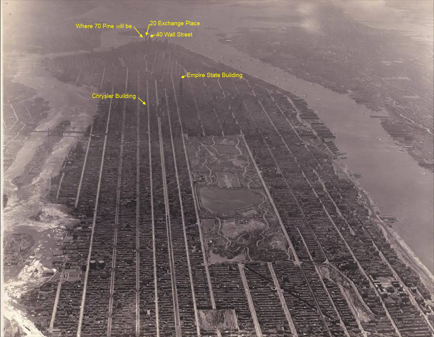 Date is definitely 1931 since the Empire State building is there but not 70 Pine Street. Wikipedia has a shot of Lower Manhattan that was also taken in 1931:
Date is definitely 1931 since the Empire State building is there but not 70 Pine Street. Wikipedia has a shot of Lower Manhattan that was also taken in 1931: 没错,而且剩下的那几栋也几乎看不清:
日期绝对是1931年,因为帝国大厦已经在上面了,但还没看到派恩街70号。
维基百科上有张曼哈顿下城的照片,也是1931年拍的:
日期绝对是1931年,因为帝国大厦已经在上面了,但还没看到派恩街70号。
维基百科上有张曼哈顿下城的照片,也是1931年拍的:
27 赞11 天前
I absolutely love the second photo. Honestly one of the most beautiful cityscapes I've ever seen.
我简直太爱第二张照片了。讲真,这绝对是我见过最美的城市景观之一。
26 赞11 天前
I’m of the belief that US cities peaked in the 1930s/40s before urban renewal policies got a hold of them. I think they’re going to need another 100 years to density further to even get back to where they were then. It’s just parking lots and freeways now a days.
我个人觉得,美国城市在 30 年代/40 年代达到过巅峰,后来才被那些城市更新政策给搞砸了。我觉得它们还得再过个一百年,等密度进一步提升,才有可能回到当初的水平。现在的城市,到处都是停车场和高速路。
80 赞11 天前
Why does it look like there are no intersecting streets
为什么看起来好像完全没有交叉路口?
132 赞11 天前
In manhattan, the avenues (north-south-ish) are wide and major, while the streets (east-west-ish) are mostly small and residential. You can see the streets if you look closely between the row houses.
在曼哈顿,大道(大致呈南北走向)又宽又主要,而街道(大致呈东西走向)大多比较窄,以居民区为主。只要你仔细看排屋之间的缝隙,就能看到那些街道了。
16 赞11 天前
Yeah, if you zoom in and look closely at several of the major avenues, you can see where the intersections are.
没错,如果你放大仔细看几条主干道,就能看出路口在哪了。
43 赞11 天前
the viewing angle allows buildings to block the view of the streets running horizontally in the image.
这个视角导致建筑把横向的街道给挡住了。
16 赞11 天前
They didn’t build cross streets until 1938. You had to take trolley 6 miles to go “around the block”.
他们直到1938年才修了横向的交叉路口。那时候你要想“绕个街区”,得坐电车跑上6英里才行。
72 赞11 天前
Those rapids in the East River?
东河里那些急流吗?
59 赞11 天前
it looks like ice. based on the trees in central park, the photo was taken in the wintertime.
那看起来像冰。从中央公园的树来看,这张照片是冬天拍的。
42 赞11 天前
Today most aerial photos are timed for reduced leaf cover. Winter is easy, if there's no snow, but there's a window in early spring where the grass is green but trees aren't leafing that is preferred. As that window moves north up thru the USA every spring there's a flurry of activity as the aerial imagery companies follow the seasons changing.
如今大多数航拍照片都选在树叶较少的时候拍。冬天比较好搞,要是没积雪的话;不过每年春天有个“黄金窗口期”,那时候草地已经绿了,但树还没长叶子,这才是航拍的首选时间。每年春天,随着这个窗口期由南向北横扫全美,那些航拍公司就像赶场子一样,忙着跟着季节变换来回奔波。
40 赞11 天前
My Sim City before I rezone everything to high density and add a bunch of trees.
我把所有地块都重划为高密度区、又种上一堆树之前的模拟城市(Sim City)。
28 赞11 天前
My mother's in this picture somewhere! She lived on 80th and West Side at this time (and was three or four years old, depending on the exact date).
我妈在这照片里的某个地方!当时她住在西区的80号大街(具体得看是哪年,那时候她才三四岁)。
22 赞11 天前
The book Time and Again is a really fascinating story comparing (via time travel) late 19th century and late 20th century Manhattan. Tons of historical research for accuracy, down to street names and addresses, interwoven with actual historical events and people.
《时空游踪》(Time and Again)这本书讲的故事真的太迷人了,它通过时空穿越,对比了19世纪末和20世纪末的曼哈顿。书里做了大量的历史考据,连街道名称和具体地址都力求精准,并把真实的历史事件和人物交织在情节里。
21 赞11 天前
Love this photo! Curious about the large cylindrical structures — I’m guessing the set in the foreground is around 110th St and 1st Ave, and the second is further south on the same avenue. And what’s the pretty park-like area just east of the cylinders?
超爱这张照片!对那些巨大的圆柱形建筑挺好奇的——我猜前景里的那组大概在第110街和第一大道交汇处,另一组就在同一条大道往南一点。还有,圆柱体东边那块漂亮的公园区域是什么地方?
21 赞11 天前
A high res version of this picture would be awesome
要是能有张这张照片的高清版就太棒了。
13 赞11 天前
and it was denser and more populated than it is now thanks to tenements
而且多亏了那些廉租房,那时候的居住密度和人口可比现在大多了。
13 赞11 天前
As a picture of "Manhattan before most skyscrapers," this photo is misleading. At first I thought that the foreground was Midtown, but it's actually Harlem. The areas with the skyscrapers are way in the back and hazy, but they're clearly there. The Empire State Building comes off a lot smaller than it really is (even by modern standards it's huge!). The buildings clustered around Central Park in this photo are 10-30 stories tall.
要说这是“大多数摩天大楼建成前的曼哈顿”的照片,那可太误导人了。我起初还以为前景是中城,结果竟然是哈林区。那些有摩天大楼的区域远在后方,看起来模模糊糊的,但确实在那儿。帝国大厦在这照片里显得比实际小多了(哪怕用现在的眼光看它也依然是个庞然大物!)。照片里中央公园周围那些楼,也就十几二十层高的样子。
20 赞11 天前
There’s nothing misleading about it. Anyone who knows the general shape of Manhattan and where Central Park is understands that the foreground is Harlem. Harlem is northern Manhattan. The photo had to be taken from quite high up to get the entirety of the island in from Harlem south. Not sure what confused you. Anyone from New York or with a passing familiarity with Manhattan can grasp this photo easily.
这照片哪有什么误导人的。只要稍微了解曼哈顿的大概轮廓和中央公园位置的人,一看就知道前景是哈林区。哈林区就在曼哈顿北边。这张照片肯定是在非常高的地方拍的,才能把从哈林区往南的一整座岛都拍进去。搞不懂你到底在困惑什么。任何纽约人,或者稍微熟悉点曼哈顿的人,都能一眼看懂这张照片。
11 赞11 天前
Robert Moses was a blessing and a curse for New York.
罗伯特·摩西(Robert Moses)对纽约来说,既是恩赐,也是灾难。
11 赞11 天前
The first NY skyscraper was the Tower Building, finished in 1889. What's interesting is that the increase in building height hasn't lead to a corresponding increase in population. Manhattan's population in 1890 was around 1.44 million. Today it's around 1.7 million. You'd think sky scrapers would have allowed for more growth. A population increase of 250,000 people over 135 years is pretty negligible. That being said the quality of housing has probably increased. People aren't dying in massive fires that often, so there is that.
第一座纽约摩天大楼是建于1889年的塔楼大厦。有趣的是,建筑高度的增加并没有带来人口的相应增长。1890年曼哈顿的人口约为144万。如今约有170万。你可能会认为摩天大楼能容纳更多人口增长。135年增加了25万人,这相当微不足道。
不过话又说回来,住房质量可能有所提高。人们不再频繁死于大规模火灾,所以这算是好事。
9 赞11 天前
It still fascinates me that city planners had the foresight and support to leave such a large tract of land unbuilt for central park. I come from a country where every bit of land is an opportunity to build.
城市规划者们当初竟能有远见和支持,留下如此大片的土地作为中央公园,这至今仍让我惊叹。我来自一个寸土寸金的地方。
9 赞11 天前
Not American. Anyone have a modern photo so i could appreciate the difference with greater precision?
不是美国人。
有没有人有现代照片,这样我就可以更精确地欣赏这种差异?
26 赞11 天前
Best one I can find with the picture from OP: https://www.reddit.com/r/pics/comments/18nqfs7/saw_this_photo_of_manhattan_in_1931_yesterday_and/
8 赞11 天前
Always fascinating to see glimpses of the old world.
看到老世界的片段,总是那么引人入胜。
8 赞11 天前
Where did all the sewage go back then?
那时候的下水道污水都去哪儿了?
18 赞11 天前
Straight and untreated into the East river, Hudson river and Harbor. However just a few years later the Ward island waste plant would go into operation. Then over the course of the next 50 years the infrastructure increased until 1986 when all of Manhattan's sewage had finally moved to being treated\* \*Except of course during heavy rains when it still overflows into the waterways because it's a combined drainage system.
污水直接未经处理地排入东河、哈德逊河和港口。然而,几年后,沃德岛污水处理厂就开始运作了。随后在接下来的 50 年里,基础设施不断完善,直到 1986 年,曼哈顿的所有污水才最终开始得到处理\*
\*当然,在暴雨期间,由于是合流排水系统,污水仍然会溢入水道。
8 赞11 天前
What’s fascinating is that the Manhattan in this photo has a higher population density than Manhattan of today. Office buildings erase entire city blocks of housing, and often times replace a block of businesses with elaborate lobby space. When you consider the office buildings and skyscrapers build shortly after this photo was taken replace crammed tenement buildings, the effect was exacerbated.
有意思的是,照片里的曼哈顿人口密度比现在的曼哈顿还要高。办公楼抹去了整整一个街区居民区,而且经常用宽敞气派的大堂空间取代了原来的商业区。当你考虑到照片拍摄后不久建造的办公楼和摩天大楼取代了拥挤的贫民窟建筑时,这种影响就更严重了。
7 赞11 天前
Are all of those low lying structures tenements?
那些低矮的建筑都是贫民窟吗?
7 赞11 天前
Amazing stuff! Thanks!
太棒了!谢谢!
6 赞11 天前
Crazy to think that when the Empire State Building was built, Canada was still a British colony
真不敢相信,想当年帝国大厦建成的时候,加拿大还是英国的殖民地